Sunday, December 5, 2010

Israel 2010

Jerusalem at night. I went to eat at restaurant Lara the first night in Israel. Delicious lamb stew. 


Wednesday, November 17, 2010

ALYN Wheels Of Love 2010

The first of the official clips of the 2010 Wheels of Love is out:


Even though the ride is over and I am back home, it is not too late to make a donation, we still need to collectively raise another million dollars to cover the shortfall for this year.

Friday, October 29, 2010

Israel

It has been a whirlwind of a trip. The Wheels of Love ride was pretty good. More details later. I'm in Bait Vgan for shabbat on my host's PC.
Anyone reading who hasn't already donated please do so on this link for US

Monday, October 18, 2010

Storm King Widdershins

Great ride over Storm King on Sunday 10/10. 9W was indeed a steep climb but the view from the overlook was excellent. Despite the narrow shoulder, the cars didn't give us any trouble. I missed the turn for Mine Rd. from 293 somehow but we ended up on US6 AKA Long Mtn Pkwy and went through Harriman, climbing 7 Lakes and Gate Hill. The fall colors in Harriman were at peak.


The only negative was that as we were riding down Gate Hill, someone in a black SUV tossed a bottle at me. It missed, sailing over the handlebars as I rode -- and I was holding my line to the right of the road, not interfering with traffic. I don't know if it was deliberate or just stupidity. Considering that a suspiciously similar black SUV on Saddle River Rd. pulled out from behind me to pass me and then cut me off and quickly stop to make a left turn, I think it was deliberate.

Tuesday, October 5, 2010

Routes to the GWB

There are a number of ways to get from northern Bergen county to the George Washington Bridge. While there are minor variations, there are also some broad groupings. I used the ridewithgps website to generate a few different routes from the intersection of County Road and Closter Dock Road to the GWB.

First I considered the straightforward route: straight up Closter Dock Road to 9W. This is 9.3 miles and 567 feet of climbing. It's a climb of 2 miles to 9W of 406 feet and that's it for climbing, the rest is modest rolling hills.

The next route option is
Piermont Road - Walnut - Pershing, which is a distance of 9.3 miles with elevation gain of 508 ft.

At about mile 5.2, one starts climbing the Palisades ridge for 1 mile gaining 300 feet. That's an average grade of 5.8% though there's a .1 mile steep section.

Churchill Road in Englewood Cliffs is a well-known NYC area climb. I considered aroute including it as well. It is 9.2 miles and 469 feet of climbing.

Over 1.1 miles about 260 feet elevation gain. So it's not as hard as it seems climbing Churchill.

The shortest route is lesser-known. At 8.4 miles and 437 feet of climbing, the route via Myrtle Ave is an example of how numbers can be deceptive: coming off Oak Trail road is a left turn and immediate climb up the hill on Myrtle.

The good part is that you coast down the other side of that hill and then a small rise is just enough to kill your momentum and let you roll to a stop at the intersection with US 9W.

Going up Van Nostrand to Jones Road is the least climbing with 420 feet gained over 9.3 miles.

Saturday, October 2, 2010

Bike MS NY

I'm riding as a sweep marshal on the 100 mile route of the Bike MS NY tour tomorrow. It should be quite a workout. I''m going to carry various tools and spare tubes and first aid kit plus lunch so it's perhaps 5 or 6 pounds extra weight on the bike. After all the eating on all the holidays recently, the workout will help get me back to trim.


Monday, September 27, 2010

Valley Forge Day 1 (part 2)

David climbs the last hill of the first day of our trip. We had a lot of climbing, mostly along suburban or country roads as we crossed Chester and Lancaster counties and into our destination: Intercourse, PA.

Marty climbs the same last hill as automobile traffic patiently follows. Overall, we had reasonable and courteous behavior from the drivers in Chester and Lancaster counties (we had very little on-road in Philadelphia other than Manayunk, which is a very bicycle-friendly community).

Valley Forge and beyond: Pennsylvania Road trip day 1 (part 1)

The Schuylkill River path resumes on the towpath, paved with gravel,  of the Manayunk Canal after on-street connections through Manayunk. 

Marty rides down Lock Street in Manayunk, a neighborhood of Philadelphia. We had stopped at the bike shop seen in the background before continuing our journey. I bought a map of the trail and a couple of Hammer gels to try out before climbing some hills after Valley Forge.

We made it the entire length of the towpath and some distance further on the regular paved trail before the skies opened up and drenched us in rain. That got Jesse's copy of the cue sheet rather soggy too. As we neared Valley Forge, the rain passed us. As you can see from the puddles, the rain had passed Valley Forge. We ate our lunch as we dried out thinking we had seen the last of the rain for the day.


Saturday, August 21, 2010

River Road workout

Last week I had to get a new front tire so I couldn't do any club rides or anything so I just did River Road. I wasn't climbing Alpine fast enough but I think I'm making progress.

Ashokan Reservoir July 18th


Friday, August 20, 2010

Pennsylvania Dutch Country Roads Adventure update

Everything is ready for the big trip. If anyone wanted to sign up last minute there is still room at the motel.
I've got the routes all planned and plotted for the Garmin. We'll take a more meandering route outbound since our rooms await us.

Monday we'll have a great tour of southwest Lancaster county and the eastern portion of York county including crossing two bridges over the Susquehanna.  For lunch on Monday we'll picnic at the Indian Steps Museum. It's closed  Mondays but there are picnic tables on the grounds and taking Indian Steps Road avoids us coming down a hill and having to make a 270 degree turn to continue on.  Dinner on Monday we will partake of the kosher dining facility at Franklin and Marshall College; hopefully we'll get there early enough to see a little of the campus. It's a little over 12 miles further to our hotel and sunset is  7:45 PM, so we'll eat a little earlier to minimize riding in dusk or dark.

Tuesday we'll take Pennsylvania Bicycle Route S back until we are near Valley Forge, where it heads north to far out of our way to Washington Crossing. The least hilly (one can't avoid hills at all but one can try to minimize climbing) route across Pawling is slightly longer: straight down Valley Forge Road is shorter but adds a fairly steep though short (120 feet or so) climb.  Once we get across the river, the Schuylkill trail is a rail trail so it's moderately rolling at most.

Monday, July 26, 2010

Big Indian

With a forecast of another sweltering hot day in New York City blaring from the radio, I put my rental car in gear and drove off to the Catskill Mountains in search of cooler temperatures with lower humidity and long climbs up country roads on which to ride my bike. Lacking a bike rack, I had managed to load my bike into the trunk by putting the back seat down and taking off its front wheel. I had found a cue sheet in the library of the New York Cycle Club; the listing of regional hill grades for Slide Mountain (Rt. 47) looked promising and so did the terrain map of the area on Google maps.

T
This statue of Winnisook, the namesake Big Indian, stands at the entrance of Indian Park.
By 7:30 AM I had arrived at Gruenbaum's in Riverdale to eat breakfast and get a sandwich to take with me for lunch. Around 8 AM, with the Bronx temperature noticeably warmer under mostly sunny skies than when I arrived, I was on the road again. After a stop for gas, a I finally arrived at my destination round 11 am: Indian Park on NY Route 28 in the town of Shandaken, Ulster County where I found no water and that the only toilet is a port-a-potty.

The climb up CR-47 was nice. I noted but didn't visit the convenience store on the east side near the bottom. The road was reasonably quiet though there were cars  it's the only way through to the valley on the other side as well as the Frost Valley YMCA with it's various camps and activities 14 miles ahead. After a short mild climb the road leveled out around 2 miles in for a half-mile. Deceptive, one thinks the ascent is a series of rolling hills and might 'attack', pushing speed up to full cruising.  This is not a good idea as one soon hits a 10% grade that gets steeper then becomes less steep only to become even steeper. After about 4 miles of this, the slope again decreases to almost level (after you've been on 10+ % grade, 5% is practically flat). This is another recovery interval, because in a half mile it gets steeper than before and stays that way until the top. The entire route is tree-lined; even at mid-day, there were plenty of patches of light shade.

When I reached the top in the hamlet of Oliverea, I stopped to take some photos.
My GPS reading at the top of the climb up CR-47 on Slide Mountain
The view ahead from the top of the ascent up Slide Mountain on CR-47. The end of the road seen here is the drop-off, a steep descent to Frost Valley.
This lake belongs to Camp Winnisook, a private club.  This lake has the highest elevation in the Catskills and is the source of the Esopus Creek.

Wednesday, July 21, 2010

Pennsylvania Dutch Country Roads Adventure update

Due to underwhelming response, I've canceled the reservation on the house in Intercourse PA and dropped plans to have a cook prepare meals for us. Instead, we are now staying in a motel  Intercourse and will make do with whatever we bring in and whatever we can buy locally. The trip price is accordingly now $285.including the "continental plus" breakfast provided by the motel.

Unfortunately, lacking a group taking 9 or more rooms I can't get a discount on the rooms.

I've got a nice route out  up the Schuylkill River trail then across the Delwarea to Valley Forge. We'll explore some of Valley Forge on the way. The plan is to climb Forge Mountain and then take Horshoe Trail across and have a nice descent. We'll see. Continuing west to Intercourse, we'll stop at another park for a pit stop.

On Monday we'll have a good day of riding. I plan to climb Welch Mountain and then head out and do a route with some covered bridges and other scenery. A swing by Strasbourg for a peek at the railroad is good too.

Our ride home Tuesday will mostly follow Pennsylvania Bike Route S with a detour to French Creek Park and Hopewell Furnace National Historic Site then back to Route S until we cross the Delaware River. We'll take the follow some back roads to our dinner stop in Elkins Park then we ride to Philadelphia or if we're ambitious and early (!) we can ride 20+ miles to Trenton. If we're tired we can take SEPTA to 30th St. station.

Monday, July 19, 2010

Choices in the Gunks

Irv riding across the Walkway over the Hudson. 
Photo by Jorge Warman

Our group of intrepid riders at the Minnewaska scenic overlook.  Photo courtesy Jorge Warman.

Tuesday, June 29, 2010

Pennsylvania Dutch Country Roads Adventure: a bike trip

This is a nice 3 day bike trip to Pennsylvania and Maryland I will lead August 22-24 to Valley Forge National Historic Park and then across Pennsylvania to a house in the town of Intercourse, in the heart of bicycle riding and Amish country. On Monday, we will spend a day riding around Lancaster and points north without our luggage. On Tuesday, we will ride back across Pennsylvania to Philadelphia and the train home, stopping for a look at French Creek State Park (a famous mountain-biking destination and campground) and the adjacent Hopewell Furnace National Historic Site  before we continue on to
dinner in the Elkin Park section of Philadelphia. After dinner, it's on to 30th St. station and the train home.

In order to make it more flexible for people outside of NYC and Long Island, the price of the trip doesn't include transportation.


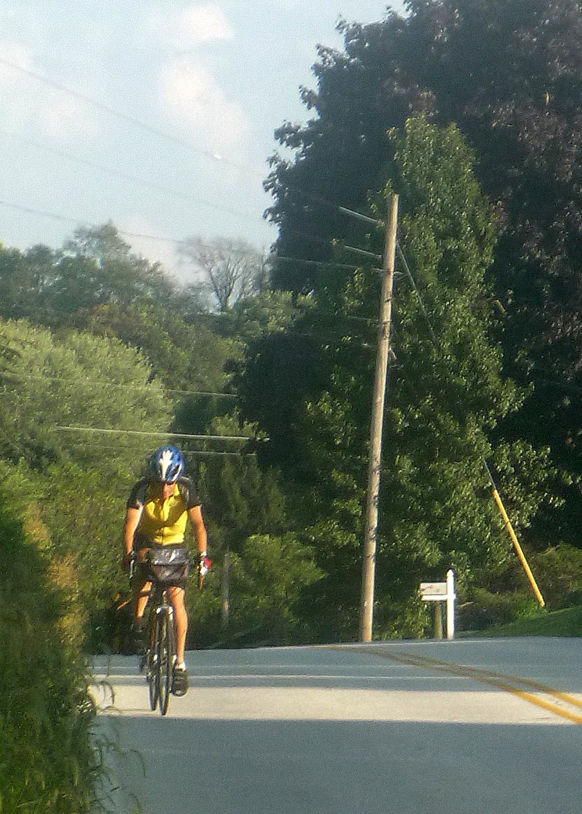
On Sunday August 22, I'll take the 7:14 AM Trenton train from NY Penn station, change for the SEPTA train to 30th St. station Philadelphia arriving 9:45 AM. Anyone not coming from NY Penn with me will meet up in the main level of the station at the north arcade waiting room.  From the station we'll ride with our panniers on our bikes at a 16 mph pace out and over the Schuylkill River Trail to Valley Forge as the first leg of our trip. After we ride around the Valley Forge site, we'll continue west across Pennsylvania with a quick stop at Marsh Creek park.

The trip price includes two nights lodging and two days worth of expertly prepared freshly cooked delicious and nutritious meals by  Sharron The Kitchen Maven : Sunday dinner, Monday breakfast/lunch/dinner and Tuesday breakfast and lunch. All meals are glatt kosher / cholov yisroel / pas yisroel. The restaurant in Elkin Park is glatt kosher. 

Of course cue sheets and Garmin routes are provided.. I've also arranged for a car service on demand to come get anyone, at their expense, who cannot continue but doesn't need emergency medical attention and take them wherever -- back to the hotel, a bike shop etc. .
 

DayMilesCruising speed - mphterrain
Sunday7016+Flat to rolling
Monday60-80 17Mostly hilly, some climbs
Tuesday8216+Rolling to flat


Before the ride
Make sure your bike is in GOOD working order. Pump up tires to the pressure specified on the sidewall. Bring essentials: helmet, 2 spare tubes, a pump, patch kit, 2 water bottles or a hydration pack of at least 50 oz., pocket food, ID, money, credit card, and if you are using Metro North or LIRR to get to/from NY Penn station you need a train pass. Eat a good breakfast consisting of carbohydrates and proteins before you leave home. Bicycle helmets are required head attire for all rides on this trip, and "ipod"-like devices are not allowed.

Lodging:
There are 3 available bedrooms.
Bedroom 1: 1 King bed and a TV, $500
Bedroom 2: 1 Queen bed and a TV $500
Bedroom 3: 2 Queen beds and a TV: each bed, $375
Bedroom 4: Women only (sharing room with Sharron) no TV, 2 beds available $300 ea.
Bring your spouse for Bedrrom 1 or 2:: $225

Deadlines:
Paying by check: $175 deposit before July 21st.  Receipt of full payment is required by August 1st. Your registration is transferable but non-refundable after July 21st. The above prices expire July 21st; after July 21st, add $150. No registration possible after August 19th.

To pay by credit card, use this Active.com event.

All prices include PA tax.


Please note: there is absolutely no smoking permitted on this trip.

Tuesday, June 22, 2010

Bagels Storm King and Beacon 6/27/2010

A long hilly ride on a long summer day, with several featured climbs including: Little Tor; Seven Lakes; Perkins, and Mine Hill. Adapted from an NYCC cue sheet for the A-SIG.

We'll stop at a kosher bagel shop in Monsey after Little Tor. After Mine Hill we'll have a long ride with scenic views from Storm King and the banks of the Hudson River as we head to the Newburgh-Beacon Bridge to catch Metro North home. 

Our goal is to take the 5:57 PM train home from Beacon but do it at Cold Spring. We might well bail at Beacon.

Bring:
- front and rear lights for night return when you get back to the city.
- lunch or buy something at the bagel shop (dairy only)...or both.
- the usual: spare tubes; tire tools; pump/inflator; water.

Planned route

Wednesday, June 9, 2010

Pizza and 7 lakes

A route for 7 Lakes from Sloatsburg with a stop for pizza in Monsey.. This has a lunch stop at mile 32 of 86.8 -- with 26.7 to the top of Perkins after lunch.  The route to Perkins and Storm King with a bagel shop stop but no Little Tor is "only" 83 miles. The route I put in is 89.9

google maps with bike route is fun.  Now if I could only get that into my garmin with every turn and get an elevation profile from google maps...

Tuesday, June 1, 2010

Storm King

June 27th is a long day.  That makes it more practical to take a long hilly ride. While we won't have all the fall colors, the Hudson Valley and Harriman Park are pleasant in summer as well.  Since we have all this daylight and need to really work up an appetite before Bubba's Bagels, we'll climb Little Tor first. That puts the bagel shop at mile 40 of 90. A bit early for lunch but the opportunity for carbs and caffeine before the rest of the climbing will help get us up the hills.

Alyn 2010

They've published the routes, and included an elevation profile. The Challenge is always difficult but this year the end of day 1 is an incredible climb.  It's hard to say exactly the distance from the graph.  but the elevation change of 354.7 meters is quite clear. Oh sure, there's a short recovery after 177.4 meters of climbing followed by more steep climbing. Looks like the whole climb is over perhaps 6 Km distance.  That only computes to a 6% grade but the catch is that downhill on the elevation chart. One thinks one could just hit 72 kph and roll up at least part of the way, but the  route makes it quite clear: you're riding down the crater wall, then turning around and climbing right back up.  The day is "only" 51 miles, and I suppose I could bail and take the bus back up the wall.  For sure at this moment I'm not in shape to handle this but I've got 4 months to get in shape.

Thursday, May 27, 2010

Get Bent

In the course of looking at various websites to recommend to my daughter Shira to help her with her electronics project for science class and understanding electricity, I found an interesting hypertext book of basic physics (I don't know the highschool physics curriculum but it looks like the material covered when I took Physics I, II, and III). It turns out that the the author, Glenn Elert, is not only a highschool science teach but a cyclist who did a cross-country bike tour on a recumbent bike which he documented. It looks quite nice.  The Physics hypertextbook is interesting but in terms of electricity there are other interesting sites as well.

Monday, May 24, 2010

Euro bicycling

Rush hour in Utrecht, Netherlands.  They're not zooming quite a fast as it appears, the video is running at a higher-than-normal frame rate (look how fast the few pedestrians scurry).  Notably, nobody is wearing a helmet.

Crossing the Susquehanna

In plotting the route for the "Capitol Invasion" leg from Philadelphia, the problem is that there's no way for bicycles to ride across any of the southeastern bridges: the Conowingo Dam road has a very narrow shoulder and Google Maps bicycling mode won't route you across and looking at the satellite images on Google Maps and Earth, I agree; US 95 is out of the question; no bicycles are allowed on US 40 Hatem bridge. The bridges across from Lancaster don't look too great but are less traveled; the problem is that is over 40 miles out of the way though great bicycling on either side of the river. The solution seems to not ride across but to utilize the bike transport services of Biller's Bikes between Perryville and Havre de Grace MD.  This service is officially part of the East Coast Greenway. By 24 hour advance appointment, $10/bike will get up to 8 bikes and riders across in one trip.

My route from Philadelphia via the Wall still needs a hotel in the Pikesville area. 

Sunday, May 23, 2010

TheManayunk Wall

I consider riding up the Wall an important part of a bike trip to/through Philadelphia even though I'm not a racer nor do I particularly follow bicycle racing.
In bicycling terminology, a "wall" is a relatively steep incline. The "Manayunk Wall," part of the course for the USPRO championship race, refers to two streets along the race's course in the northwest section of Philadelphia, Levering Street and Lyceum Avenue. The bottom of the "wall" begins at Main Street and Levering Street in the neighborhood of Manayunk, proceeds shortly on the well-worn cobblestone Cresson Street under the elevated railway, then proceeds back onto Levering Street. S... most of the Wall is part of Levering Street, but suddenly becomes Lyceum Avenue at Tower Street. The steepest section, a 17-percent grade, commences just after the slight left turn (when going up) at the intersection with Tower Street, and ends at the intersection with Fleming street. It becomes slightly less steep on the stretch with "O'Brien's" as it crosses Manayunk Avenue. It nearly flattens out and is considered to end at Pechin Street in Roxborough..... The right turn off Lyceum Avenue onto Pechin Street begins "The Fall from the Wall."

Capitol Invasion leg 2 plan

No way can we get to Pikesville MD from Philadelphia in a day. We should not only see the Wall in the Philadelphia area but also take the NCR trail from York PA to Ashland MD. That's over 156 miles after having done 95 the day before.

I'll have to find a way to break this up into two segments. That makes this trip into a 4 day / 3 night one with Wednesday return.

Nowhere to stop for lunch either, just dinner from the kosher food place at Dutch Wonderland in Lancaster area which supposedly can sell you food without a park admission.

Pkesville area has a number of kosher restaurants and there are hotel options in the area as well.

Washington trip leg 1: Philadelphia

Newark to Philadelphia is the first leg of the "Capital  Invasion" bike trip I'm planning for August 22nd. I found a lovely B&B in the Elkins Park area but over $300/night is way out of our budget. I found a few hotels in downtown Philadelphia for under $130/night as listed and the hope that priceline will get us an even better rate.  This leg runs 92.3 miles.

The restaurant, Max and Davids, in Elkins Park sounds much better than either option for dinner in Philadelphia itself -- I've eaten at Maccabeam, it's OK --, but it means 12 miles after dinner to the hotel though it gives us an opportunity to ride through Valley Forge. This variant is 96.9 miles. 

There is a hotel in Chestnut Hill but it's expensive and out of the way. At least in downtown Philadelphia, breakfast options exist.

Monday, May 17, 2010

Cherry Hill super century

A fabulous day on the bike yesterday. We started with four riders and myself. Before we reached 20 miles, we had one flat tire. After fixing the flat, that rider dropped off the ride at Long Branch station. The rest of us continued on to enjoy a ride along the ocean, including a stretch on a boardwalk -- which changed from wood planks to stone along the way. We saw lots of nice homes and stopped for lunch in Deal at Jerusalem II Pizza. We stopped for a look at the famous Sea Girt Lighthouse. Pretty, but surprisingly low tower. After Sea Girt, we turned westward toward Lakewood and, as planned in advance, bid farewell to another rider who stayed to explore the beach communities further before taking the train home.

The three of us remaining rode on at a very brisk pace down the Edgar Felix bikeway and on country roads and residential streets into downtown Lakewood for a snack stop. From then on, it was a long hard fast push to Cherry Hill. Construction on Highway 70 / Marlton Pike West that eliminated the nice wide shoulder we had enjoyed as well as one lane of traffic, forcin us off the direct route to dinner and through more back roads. We reached dinner shortly before 8PM.

The roads of south NJ were quite pleasant overall.

Cherry Hill super century by dhudes at Garmin Connect - Details

Monday, May 10, 2010

Cherry Hill Adventure

It's a narrow window in time after weather warms up and before the summer season begins on the Jersey Shore. I've plotted a route for a fast, flat ride for May 16th instead of doing Montauk again. The route takes us along the shore through many of the beach communities and past the Sea Girt Lighthouse before it turns inland through Lakewood and the Lebanon / Brendan Byrne Forest, using several paved greenways along the way as shortcuts. It's a long day, but the route from the start at Newark PATH to dinner at Cherry Grill should prove quite nice after Elizabeth. It's 125 miles to dinner so we've got to keep moving at a 17 mph cruising speed to maintain a 14 mph moving average. Lunch in Lakewood is a definitely needed stop around mile 70 at Bagel Nosh.

Return transportation is on NJ Transit from Cherry Hill station on the Atlantic City line, only 2.7 miles down the Marlton Pike from dinner. Service to Trenton via Philadelphia is fairly quick: one gets back to NY Penn station about 3 hours 30 minutes after boarding in Cherry Hill. We have to ride fast and keep stops to a minimum such that we finish dinner to reach the station for the 6:59 PM; next train is 8:53 PM. We change trains for NJ Transit in Philadelphia. Amtrak doesn't allow bikes on board Northeast Corridor trains.

Wednesday, May 5, 2010

Wednedsday night River Road

As the shadows lengthened early this evening, I clipped in and rode down to the West Side Greenway headed for the GWB and Palisades Park for an evening ride. I noticed that the connecting section of Greenway at 84th st. is looking pretty good but the gates are still closed; hopefully, this summer it will open at last. As I spun up the hill from the path by the river's edge to the promenade in Riverside Park, someone passed me. I took this as a sign that I was going too slow, not pushing hard enough -- so I up-shifted one gear and pushed myself for as fast a standing climb as I could manage under conditions (it's not just the slope, it's the pedestrians in both directions and the occasional oncoming cyclist). I continued pushing fast and hard up on the promenade and couldn't quite close the gap completely. I lost track of the faster cyclist while dodging pedestrians.

Back down on the Greenway at 96th St., I shifted to my 3rd (biggest) chain ring and and pretty small gear. I know I was doing about 20 mph for a while. The hill up to the hill to Riverside Drive was tough. I remember glancing down and seeing about 11% there but Training Center claims only 9%; similarly, I thought the steep section of the switchback was 18% but TC says 11%.

The ride from Edgewater down was lovely. The climb up to Alpine was great, I pushed as hard as I could -- even standing for some sections, which I seem to have improved at somewhat. It's been a busy stressful time at work and this sure helped blow off steam.

Sunday, May 2, 2010

Stony Point results

Shimon and I met up with Karen on the NJ side of the GWB and headed off up US-9W. As we rode through Alpine, Shimon suddenly found that he couldn't downshift his chain ring: he was stuck on the big ring. We all pulled into the Palisades Park HQ and had a look to see what was wrong. While there, we met up with Yehuda, one of my fellow Challenge riders from the 2009 Wheels of Love. He also looked but didn't find anything wrong either -- cable had tension and everything looked right. Yehuda suggested we take Shimon to either Piermont Bicycle Connection or further up on 9W to Toga Nyack.

I felt Shimon would have great trouble with the hills on 9W beyond Piermont and the best thing was to head for Piermont. So much for my carefully planned ride.


Shimon's problem was quickly resolved when we got to the store. That left me with the problem of us several miles east of our route, not to mention on the wrong side of a very steep ridge. I rerouted us on-the-fly to proceed north on the route I'd planned for our return. We went through Piermont and the towns north of it and into South Nyack Beach Park to pick up the bikeway through the park.


After exiting the park, we followed NYS Bicycle Route 9 the rest of the way to the turn for Stony Point Park. When we arrived at the park gate at about 12:40 PM, we found a sign "site closed. No restrooms available". We decided we were hungry and sat on some rocks near the gate overlooking a small pond and wetlands to eat our lunch.

Everyone was hot and tired. We took 9W back through Stony Point, stopped at a store and got cold drinks then continued on south. As we progressed, I saw that Shimon and Karen were not keeping up and having difficulty climbing. I changed our route from hauling down 9W to veer inland -- and downhill -- to take Piermont Road back through to Tenafly. It's a much less hilly route until of course the end when you have to get back up across the ridge. We stayed on CR-501 the whole way and climbed up Palisades Ave. . At the top of Palisades, Karen and I sat on a bench for a while to wait for Shimon, then headed on to the GWB and home.

Stony Point try 2

Tomorrow morning we're off to attempt Stony Point. I listed it as an NYC B16 ride. If the rain comes or we're not going fast enough, we'll turn around at the C-Mart in Central Nyack 19 miles from the GWB and take Piermont Road back instead of 9W. I hope we can push on to do Little Tor Road, then hook down and pick up the regular return route.

Friday, April 30, 2010

Rained out again

The weather forecast for New Paltz is getting worse every day. The rain in the afternoon is enough, and then add thunderstorms from 1 PM on.

The forecast for the lower Hudson valley looks promising. At least the morning is clear so an 8 AM start should get the ride up past Tweed at the least. If we get caught in the rain coming down Riverside Drive it's very different than getting caught in the rain on Clove Road in Ulster County (or coming down US44 from Minnewaska in the rain...).

Wednesday, April 28, 2010

Biathlon ride

The ride on April 18th went off pretty well, though we had a small group. My co-leader Erica and I left Central Park Boathouse with Lori and Carolina; after a nice ride through the south Bronx we were joined by Scott at the west end of Pelham Parkway. The pace was slower than anticipated and we had more and longer stops than I'd planned but we still got to our destination, Life The Place To Be, at around 1:15 or so. I had some trouble reaching the pizzeria to place our order for delivery: called three times with no answer. On the last leg of the South County Trailway I zoomed ahead to our exit from the trailway, and placed a successful call to get our food which came in 45 minutes.

The timing of our food delivery worked out just right: the girls went "rock" climbing right after we arrived. I tried it, but the route I was on was too cramped and my shoes too stiff so I quit about three-quarters of the way up and rappelled down. After pizza, it was time for arcade games. I played many rounds of "Time Crisis". Carolina and Lori danced away on "Dance, Dance Revolution". After our hour of play time was up, we headed back down to the Bronx. Everyone was fed and happy and picked up the pace considerably -- cruising chatting with Erica on the southern leg from Redmond Park, I noticed that Carolina and Lori had zipped off ahead so I sprinted to pass them with Erica hot on my rear wheel.

A great time was had by all.


Erica climbs


Erica, Lori and Carolina climb the wall at Life


Erica and Lori rappel down after reaching the top


Lori dances away on DDR


Monday, April 26, 2010

Meet the Gunks

This Sunday I'm off to the Shawangunks ("Gunks") to do some more climbing and escape the crowds descending on NYC for the 5 Borough Bicycle Tour. I'm changing the route a little this year to use the Walkway over the Hudson instead of the Mid-Hudson Bridge and to go through some residential New Paltz streets to get to the historic section of Hugenot St. . This year we're leaving an hour earlier: we'll meet 7:30 AM at Grand Central Terminal for the train to Poughkeepsie. I hope this provides enough time to climb to the top of Minnewaska State Park. The carriageways are always getting hit with storm damage in the winter but the road to the top itself is at least nominally paved. If it's not accessible, we'll stop at the shores of Lake Minnewaska for a photo op and potty break before we climb back up to the state roads home.

4/29/2010 updated the link to the route so that it actually works

Sunday, April 11, 2010

Stony Point

I looked at the route outbound more closely with terrain on. Fine-tuned route. Now it's a nice day and I've done my errands so let's see how fast I can get out to Clausland. Hmm....think I'll bring my bike light for the return just in case.

Friday, April 9, 2010

Biathlon ride

The link is to the Manhattan/Bronx portion of the ride, to/from the trailway entrance.
From there it's straight up to Ardsley.

Scouting this, I really didn't care much for riding on McLean Ave. -- slow, crowded. Still, no time to ride up north and then go over to Ardsley.

The better way is to take the Moshulu Greenway over to Van Cortlandt Park and get on the "Old Put" trail -- but that's dirt with railroad tracks etc., and not improved dirt like the rail trail up in Orangeburg. I did it once on my touring/cyclocross bike but wasn't too happy about it. If we have a week of dry warm weather, it's a possibility but if there's any rain between tomorrow and April 18th forget it: too muddy, take the roads around VCP.

Sunday, April 4, 2010

Manhattan - Bronx scouting

I took a couple of hours today to scout the possibility of taking my April 18th ride to the Bronx via Wards Island and Randall's Island. My route was Central Park East Drive - E. 90th St - 1st Ave - E. 102nd St. - Wards Island - across Wards Island to Randall's Island to the walkway to the Bronx. The hope was to have better cycling for the 25 or so blocks difference by using the Greenway on Ward's Island rather than slogging up 7th Ave. to 125th St.

The reality was somewhat mixed. E. 90th street needs repaving, particularly as it crosses 2nd Avenue and the entire section to 1st. While 1st Ave has a bike lane the pavement isn't in good shape there either.

The best approach is up through Central Park then over to the East Side Greenway and over Wards Island Bridge.

from the Boathouse to the South County Trailway

Stony Point scouting

The smooth asphalt of the Joseph Clarke rail trail in Orangetown made for a fast ride on a glorious spring day this past Friday. I had taken the day off from work to clear my mind and reduce stress. I have a ride to Stony Point on April 25th and I'm not in shape to ride it at the speed I listed -- particularly my climbing is relatively weak and it's a hilly and long ride.

I did Stony Point last year but I want to change the route. I tried out the new Google maps bicycle route feature and it suggested using the Joseph Clarke Rail Trail then the Raymond Esposito Rail trail continuation (Russell Nelson's rail trail sitemap lists it all as the Joesph Clarke though the signage on the route clearly changes the name of this rail trail of the old Northern Railroad of New Jersey route), offering an interesting possibility of a long distance of car-free cycling from Oak Tree Road into Nyack (or vice-versa).

The trail started out really nice. Then the asphalt ends and the trail continues as single track with some crushed gravel and dirt. A fork in the road offers Blauvelt to the left and Piermont and Nyack to the right. I continued on the right fork, which quickly crossed CR 340 at the intersection of CR303 with US 9W crossing a block or so away. After crossing 340, the trail opens up to a wider dirt road -- no gravel. Conditions weren't too great but passable and I continued on. When the trail turns into the Esposito trail it gets gravel and hardpack, much better. Further on one has a choice as the trail forks slightly left and uphill. I continued ahead into Hader County Park which had pretty decent conditions. Lots of debris from the storms but mostly cleared -- a big branch across the route had an opening cut through it.

Overall, not bad but I have a cyclocross frame with 28mm Continental Gatorskins (kevlar belt) tires; my Brooks B-17 stretched leather saddle worked well when I kept my "sit bones" back at the rear of the saddle. The short dirt segment from the paved section to exit onto 340 is acceptable to get us out on 340 to head for Tweed and thence onto Bradley and head for Little Tor Rd. (though taking Orangeburg Rd. around to get to climb Clausland's 11% grade to Tweed and Bradley is good...). For the return route, when we get off the Hook Mountain we just get on Piermont Ave. and follow it back around to the rail trail back to Oak Tree then over to Piermont Rd and back to Englewood Cliffs where of course there is more climbing to finish the day :-)

The route out has to bypass the entrance to Palisades Malls. That's an ok thing if you're headed east but not west since there are cars entering and exiting. Of course, bypassing means more climbing. The current route looks real nice and pretty different from the route that Steve Sakson's crew will take the day before. Climbing Tweed is a nice prelude workout to what we'll do in Mountainview.

The climbing and turning gets us onto CR33 for miles and miles (about 9.6) even as it changes names.

The route home is easier and takes us through Hook Mountain then along the river.

Tuesday, March 23, 2010

Upcoming rides

Besides the April 18th ride, I'm once again doing Stony Point this year on April 25th. The plan is to colead with Ken Williams again. It's an NYCC listed ride. It is supposed to also have 5BBC listing but apparently Ed RAvin edited my ride description and that revised description caused outrage amongst the leaders ofthe ride the day before and Ed Ravin then withdrew the listing instead of sticking with my original succinct description.

I've got a plan for a new route this year. Makes it less of a "classic 9W" ride but rail trails can make for faster cycling. Also, on the way home we should take the opportunity to enjoy the late afternoon Hudson River views.

Google bicycling maps:
The outbound route my way which not only uses rail trails but the nice hilly and quiet Tweed and Bradley.

return route along the river. Of course we still climb Churchill Rd on the way home.

It will be a long day if we don't keep up the pace.